
-
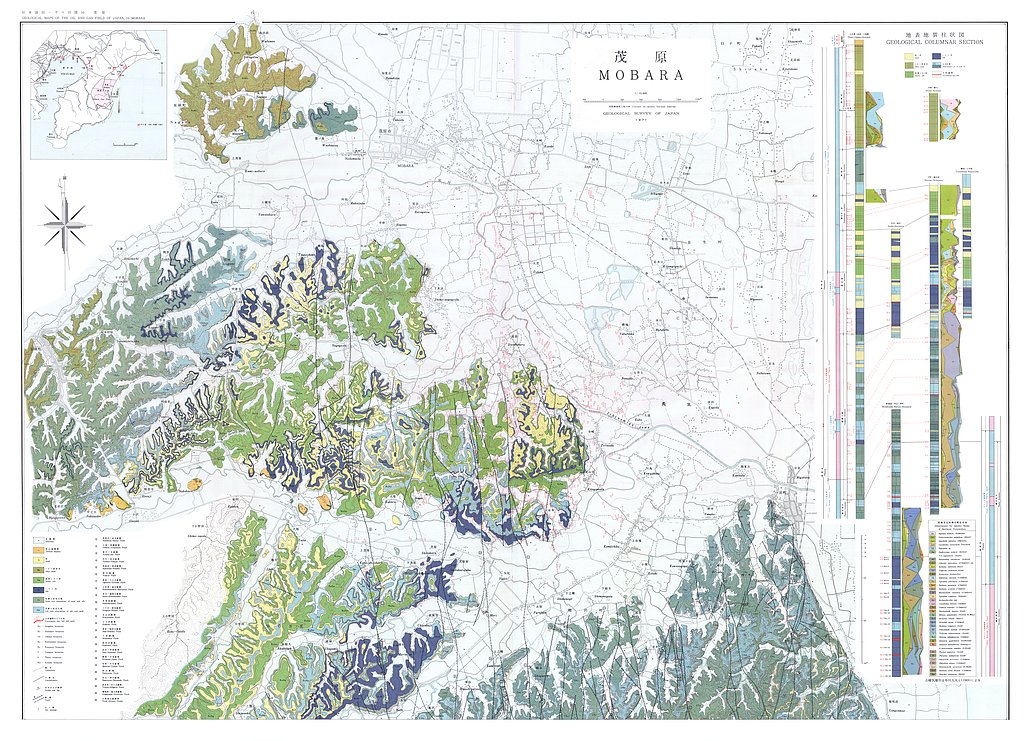
茂原,1:15,000,1:50,000 (1971)
地質調査総合センター名称: 茂原,1:15,000,1:50,000 / Mobara, 1:15,000, 1:50,000 著者: 伊田 一善, 石和田 靖章, 河井 興三, 牧野 登喜男, 三梨 昂, 本島 公司, 小野 映, 大山 桂, 品田 芳二郎, 高田 康秀, 鶴田 均二, 内尾 高保, 安国 昇, 加々美 時寛, 茅山 芳夫, 小野寺 公児, 金子 政利,... -
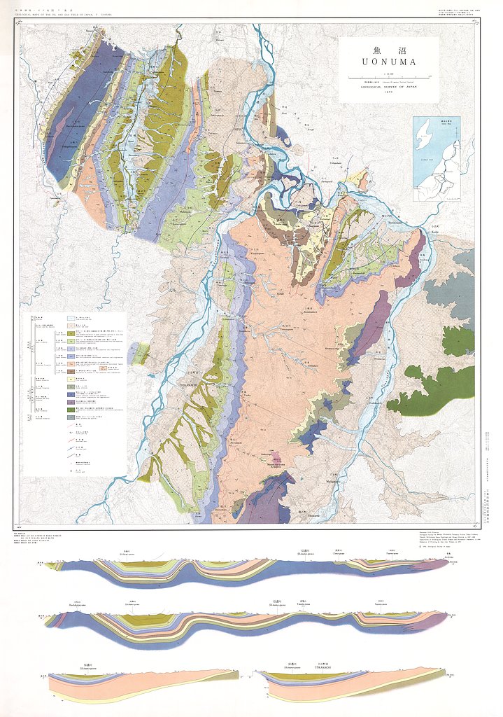
魚沼,1:50,000および地質説明書と地質柱状図 (1972)
地質調査総合センター名称: 魚沼,1:50,000および地質説明書と地質柱状図 / Uonuma, 1:50,000 and Study on the Stratigraphy and Geological Structure of the Uonuma District, Niigata Prefecture, Japan and Geologic Columns in... -
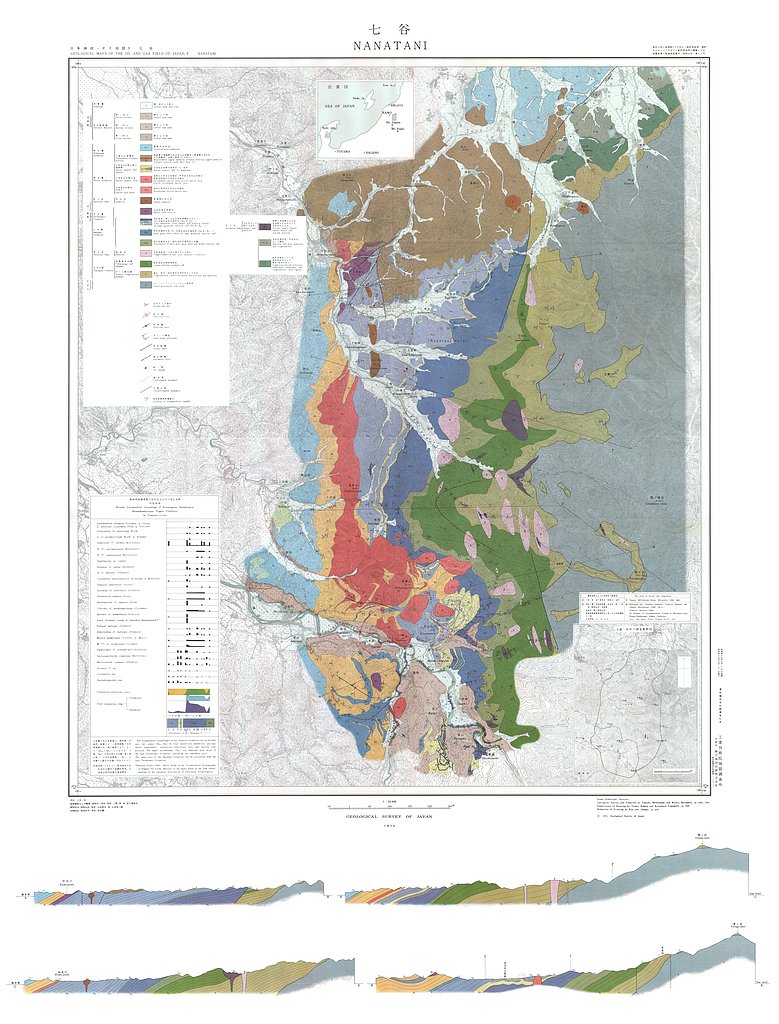
七谷,1:25,000 (1970)
地質調査総合センター名称: 七谷,1:25,000 / Nanatani, 1:25,000 著者: 三梨 昂, 宮下 美智夫 / MITSUNASHI Takashi, MIYASHITA Michio, 発行年: 1970 シリーズ: 日本油田・ガス田図 / Geological Maps of the Oil and Gas Field of Japan 発行者:... -
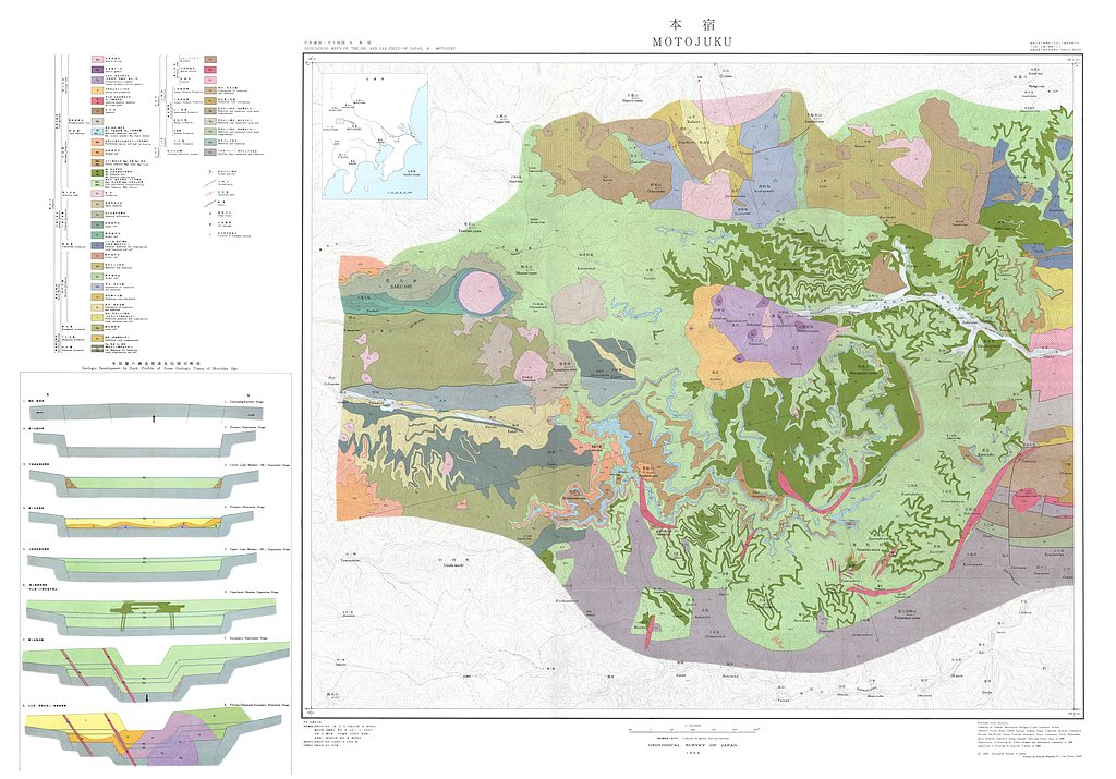
本宿,1:25,000 (1969)
地質調査総合センター名称: 本宿,1:25,000 / Motojuku, 1:25,000 著者: 三梨 昂, 井島 信五郎, 鈴木 尉元, 藤田 至則, 周藤 賢治, 野村 哲, 山岸 いくま, 吉村 尚久, 井部 弘, 磯貝 基一, 川北 敏章, 吉沢 荘夫, 倉島 陽一, 金原 啓司, 酒井 助太郎, 新井 節, 新井 房夫 / MITSUNASHI... -
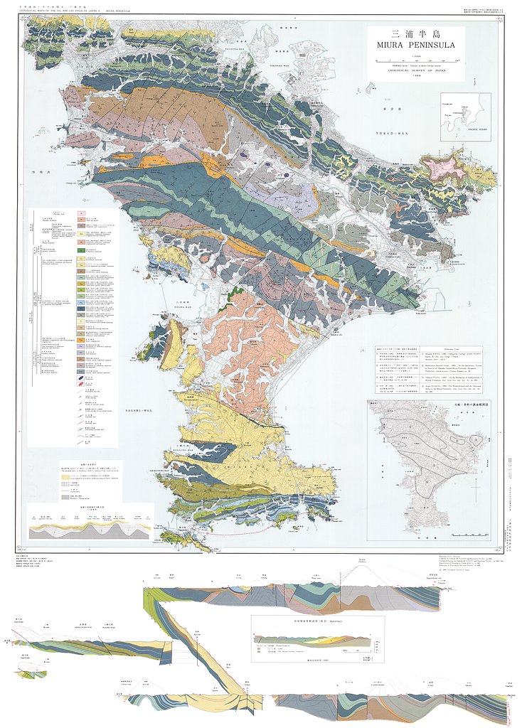
三浦半島,1:25,000 (1968)
地質調査総合センター名称: 三浦半島,1:25,000 / Miura Peninsula, 1:25,000 著者: 三梨 昂, 矢崎 清貫 / MITSUNASHI Takashi, YAZAKI Kiyotsura 発行年: 1968 シリーズ: 日本油田・ガス田図 / Geological Maps of the Oil and Gas Field of... -
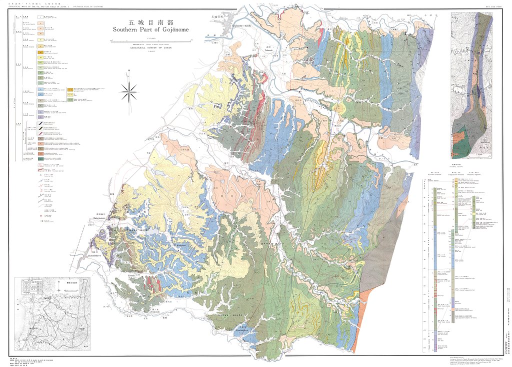
五城目南部,1:15,000 (1963)
地質調査総合センター名称: 五城目南部,1:15,000 / Southern Part of Gojonome, 1:15,000 著者: 三梨 昂, 影山 邦夫, 品田 芳二郎, 牧野 登喜男, 安国 昇, 本島 公司, 大沢 穠, 高橋 稠 / MITSUNASHI Takashi, KAGEYAMA Kunio, SHINADA Yoshijiro, MAKINO... -
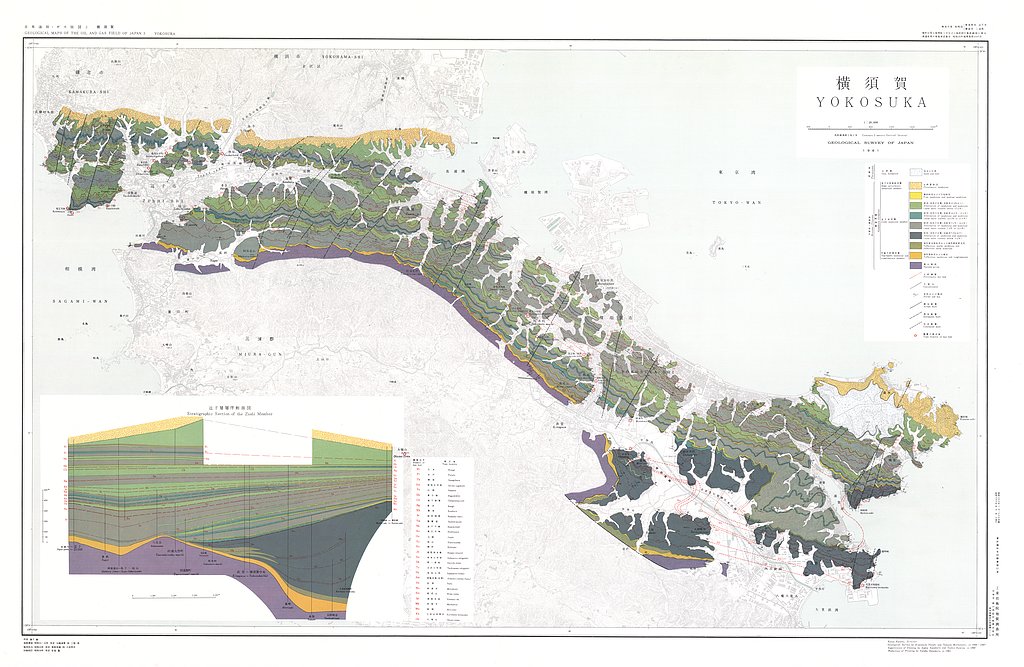
横須賀,1:20,000 (1962)
地質調査総合センター名称: 横須賀,1:20,000 / Yokosuka, 1:20,000 著者: 矢崎 清貫, 三梨 昂 / YAZAKI Kiyotsura, MITSUNASHI Takashi 発行年: 1962 シリーズ: 日本油田・ガス田図 / Geological Maps of the Oil and Gas Field of Japan 発行者:... -
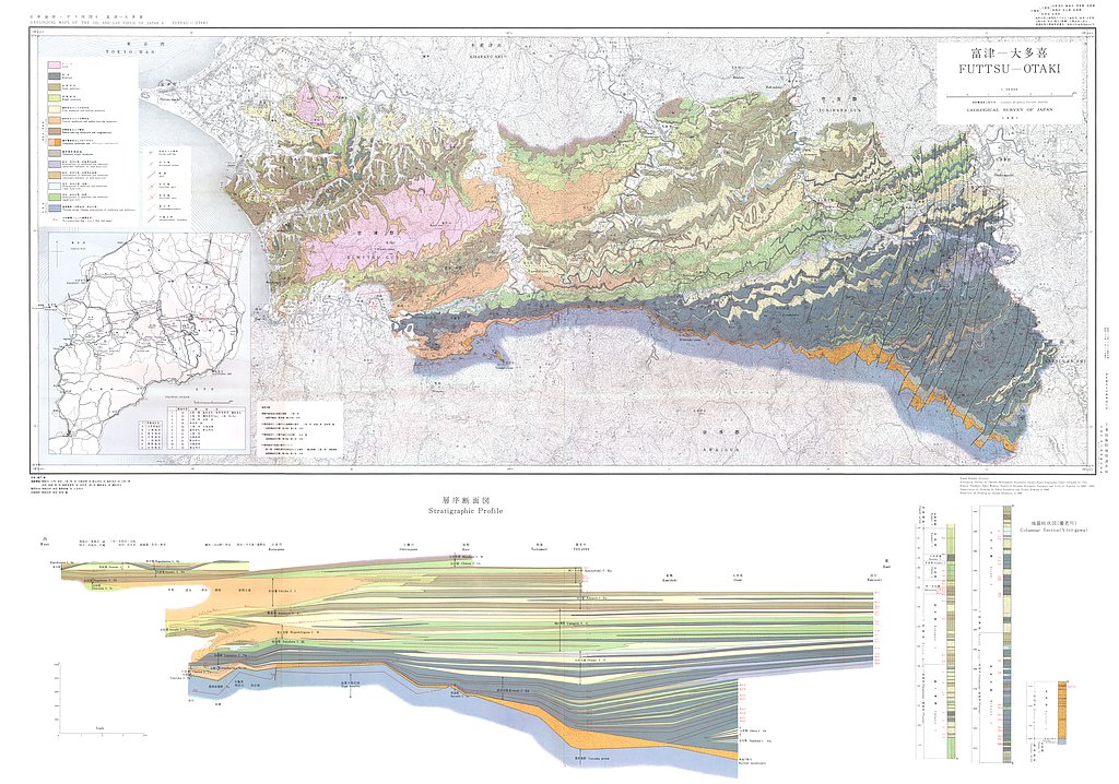
富津−大多喜,1:50,000 (1962)
地質調査総合センター名称: 富津−大多喜,1:50,000 / Futtsu - Otaki, 1:50,000 著者: 三梨 昂, 矢崎 清貫, 影山 邦夫, 島田 忠夫, 小野 映, 安国 昇, 牧野 登喜男, 品田 芳次郎, 藤原 清丸, 鎌田 清吉 / MITSUNASHI Takashi, YAZAKI Kiyotsura, KAGEYAMA Kunio,... -
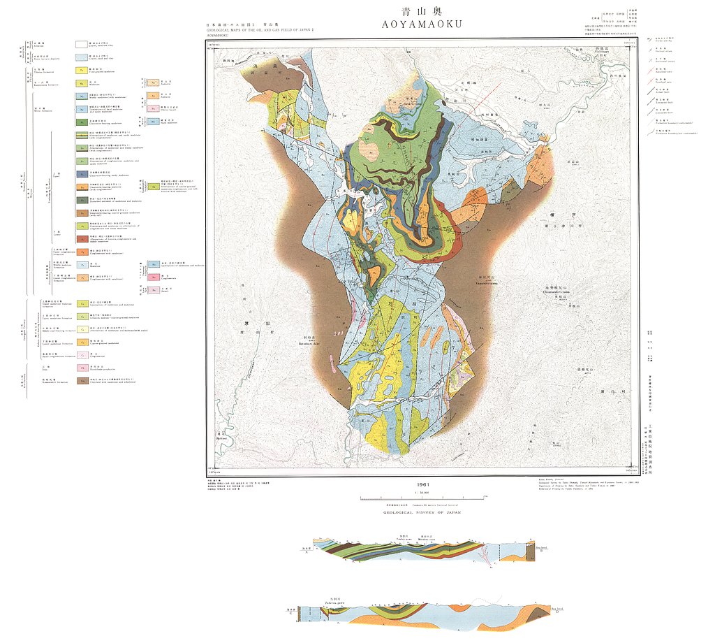
青山奥,1:50,000 (1961)
地質調査総合センター名称: 青山奥,1:50,000 / Aoyamaoku, 1:50,000 著者: 島田 忠夫, 三梨 昂, 矢崎 清貫 / SHIMADA Tadao, MITSUNASHI Takashi, YAZAKI Kiyotsura 発行年: 1961 シリーズ: 日本油田・ガス田図 / Geological Maps of the Oil and... -
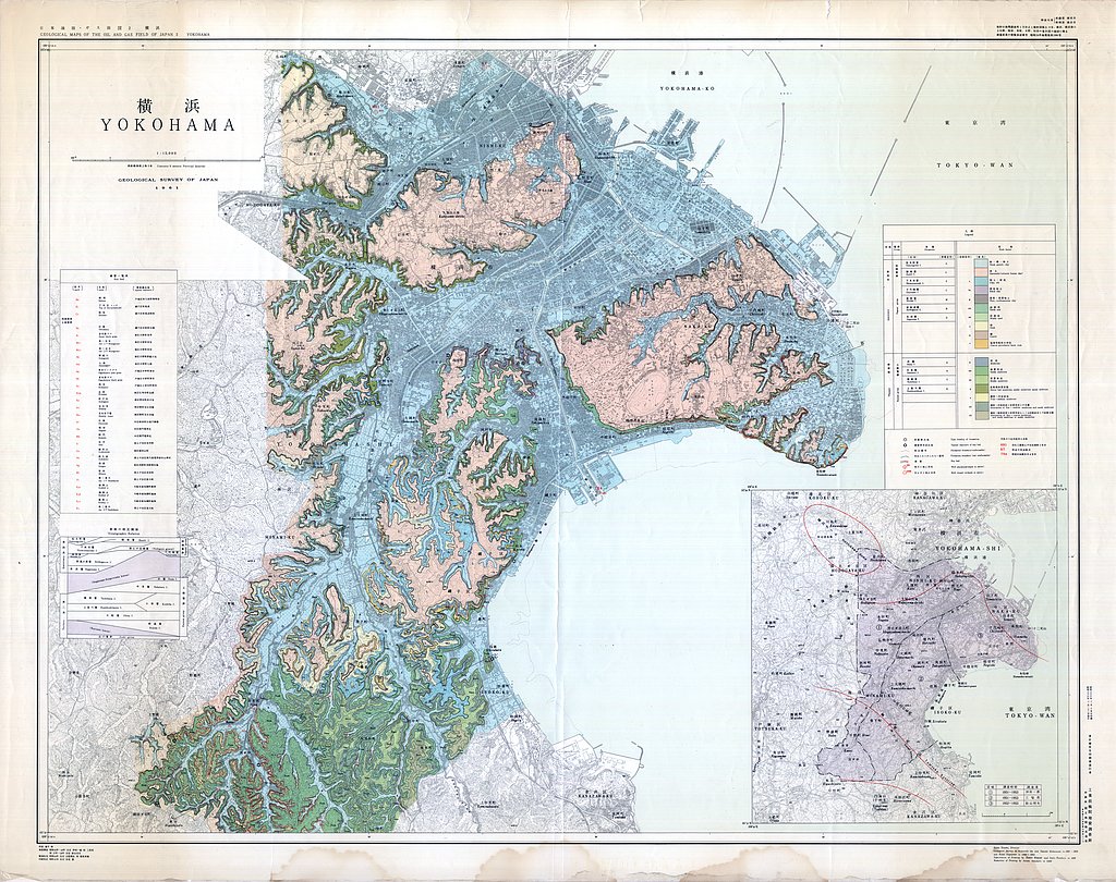
横浜,1:15,000 (1961)
地質調査総合センター名称: 横浜,1:15,000 / Yokohama, 1:15,000 著者: 伊田 一善, 三梨 昂, 影山 邦夫 / IDA Kazuyoshi, MITSUNASHI Takashi, KAGEYAMA Kunio 発行年: 1961 シリーズ: 日本油田・ガス田図 / Geological Maps of the Oil and Gas... -
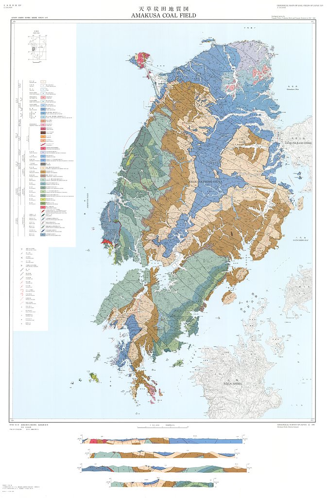
天草炭田地質図,1:50,000「熊本県天草炭田の地質及び石炭鉱床」 (1997)
地質調査総合センター名称: 天草炭田地質図,1:50,000「熊本県天草炭田の地質及び石炭鉱床」 / Geological Map of the Amakusa Coal Field, 1:50,000, and Explanatory Text 著者: 高井 保明, 坊城 俊厚, 原田 種成 / TAKAI Yasuaki, BOJO Toshiatsu, HARADA... -
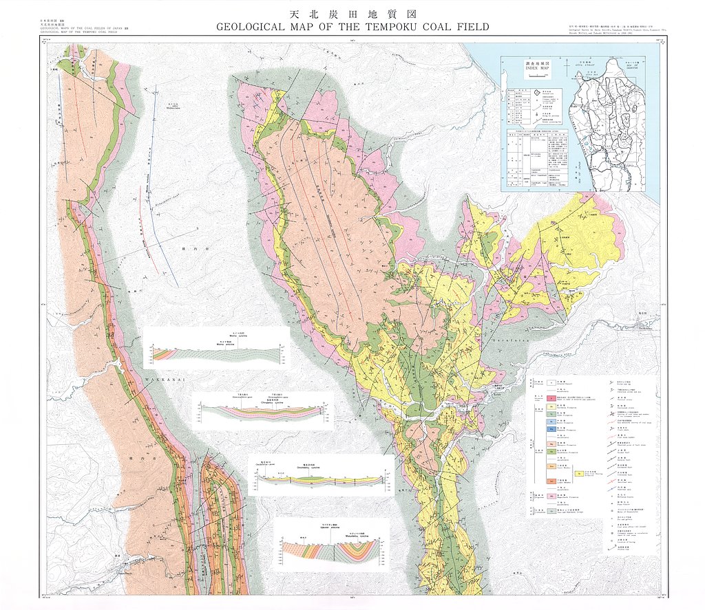
天北炭田地質図,1:25,000, 天北炭田炭層対比図ならびに地区別炭柱図 (1979)
地質調査総合センター名称: 天北炭田地質図,1:25,000, 天北炭田炭層対比図ならびに地区別炭柱図 / Geological Map of the Tempoku Coal Field, Hokkaido, Japan, 1:25,000, Correlation Chart of Coal Seams and Columnar Sections of them in... -
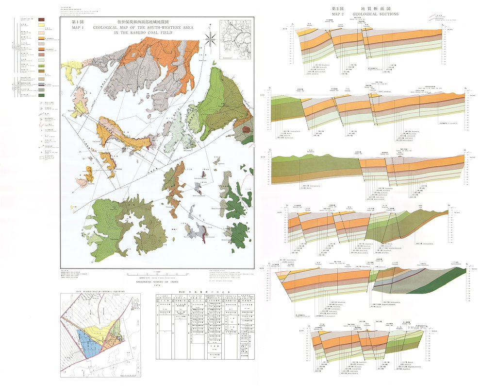
佐世保炭田西南部地域地質図,1:10,000 (1974)
地質調査総合センター名称: 佐世保炭田西南部地域地質図,1:10,000 / Geological Map of the Southwestern Area in the Sasebo Coal Field, Northern Kyushu and its Explanatory Text, 1:10,000 著者: 古川 俊太郎 / FURUAKAWA... -
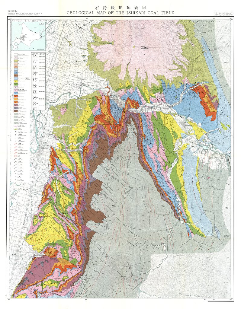
石狩炭田地質図,1:50,000および石狩炭田地質図編集について (1973)
地質調査総合センター名称: 石狩炭田地質図,1:50,000および石狩炭田地質図編集について / Geological Map of Ishikari Coal Field, 1:50,000 著者: 徳永 重元, 坊城 俊厚, 河野 迪也, 佐々木 実, 植田 芳郎, 佐藤 良昭, 井上 英二, 鈴木 泰輔, 尾上 亨, 中尾 征三, 曽我部 正敏, 根本 隆文, 佐川... -
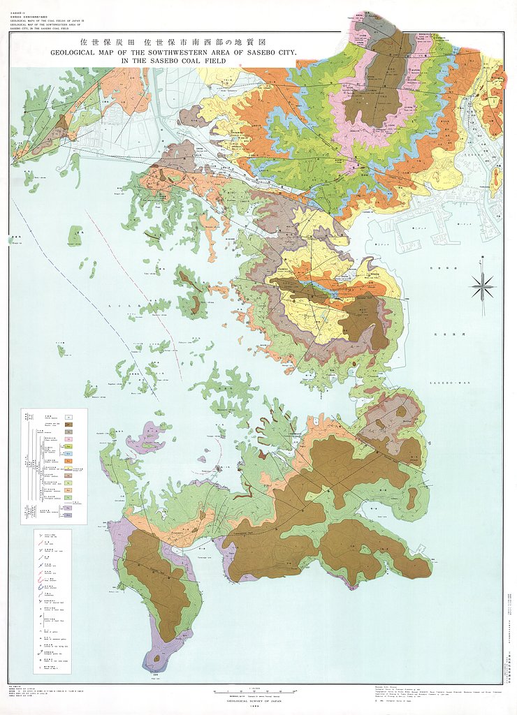
佐世保炭田佐世保市南西部地域地質図,1:10,000 (1969)
地質調査総合センター名称: 佐世保炭田佐世保市南西部地域地質図,1:10,000 / Geological Maps and Explanatory Text on the Geology and Coal Seams of the Southwestern Area of Sasebo City in the Sasebo Coal Field, Northern... -
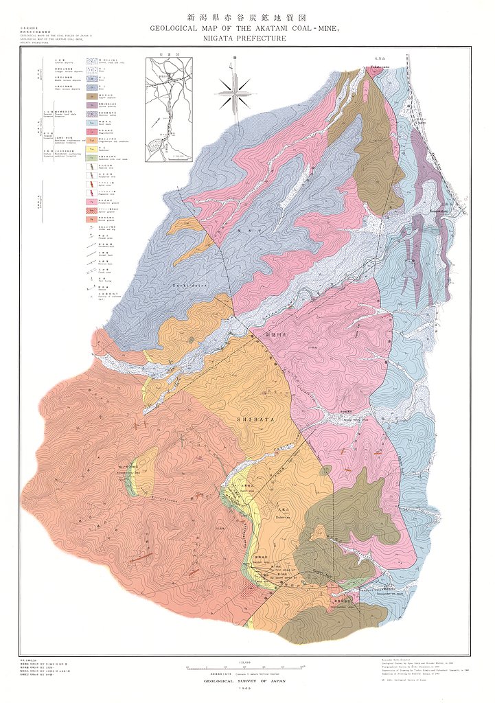
新潟県赤谷含炭地地域地質図,1:5,000 (1969)
地質調査総合センター名称: 新潟県赤谷含炭地地域地質図,1:5,000 / Geological Maps and Explanatory Text on the Geology and Coal-Seam at Akatani Coal-Mine, Niigata Prefecture,1:5,000 著者: 井上 絢夫, 松井 寛, 小松 つよし, 立花 栄一 /... -
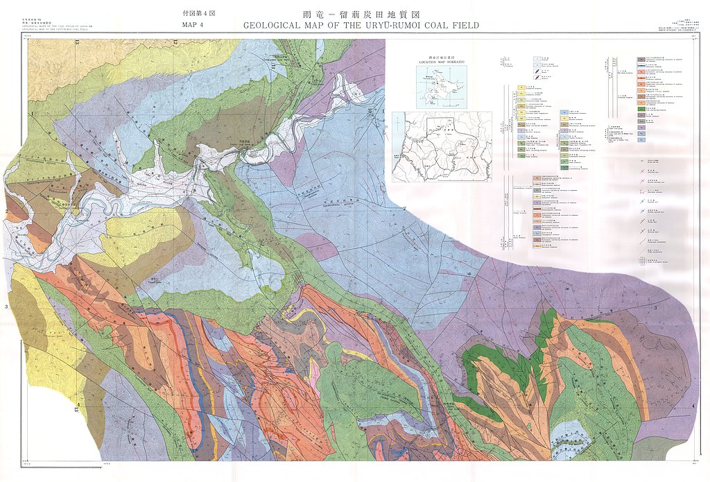
雨竜−留萌炭田地域地質図,1:20,000 (1968)
地質調査総合センター名称: 雨竜−留萌炭田地域地質図,1:20,000 / Geological Map of the Uryu-Rumoi Coal Field with Explanatory Text,1:20,000 著者: 須貝 貫二, 藤原 清丸, 福田 理, 春城 清之助, 星野 一男, 上島 宏, 河野 迪也, 久保 恭輔, 宮下 美智夫, 根本 隆文,... -
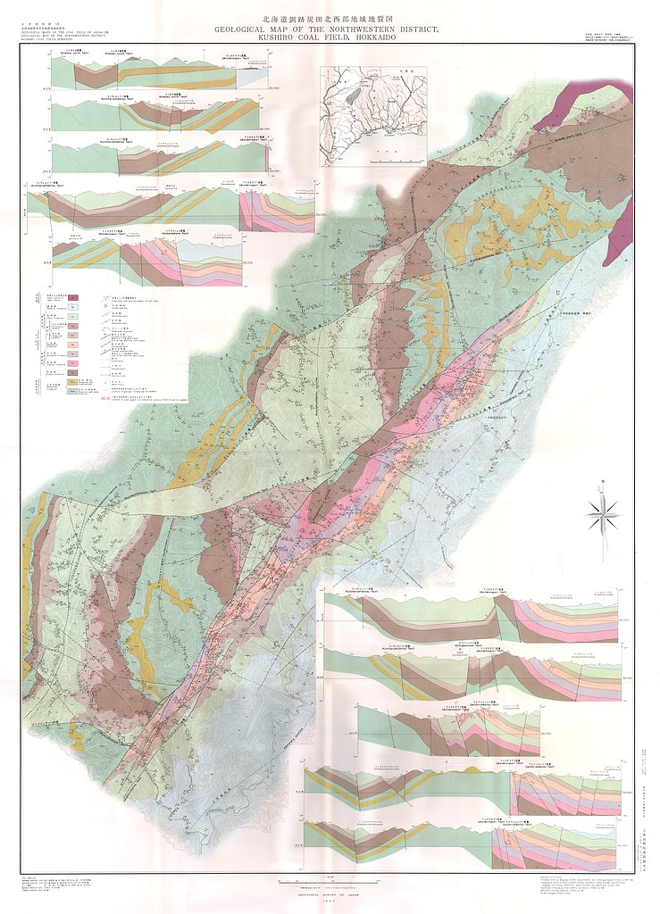
釧路炭田北西部地域地質図,1:20,000 (1967)
地質調査総合センター名称: 釧路炭田北西部地域地質図,1:20,000 / Geological Maps and Explanatory Text of the Northwestern District, Kushiro Coal Field, Hokkaido,1:20,000 著者: 曽我部 正敏, 星野 一男, 井上 英二, 鈴木 泰輔, 藤本 弁蔵, 橋本... -
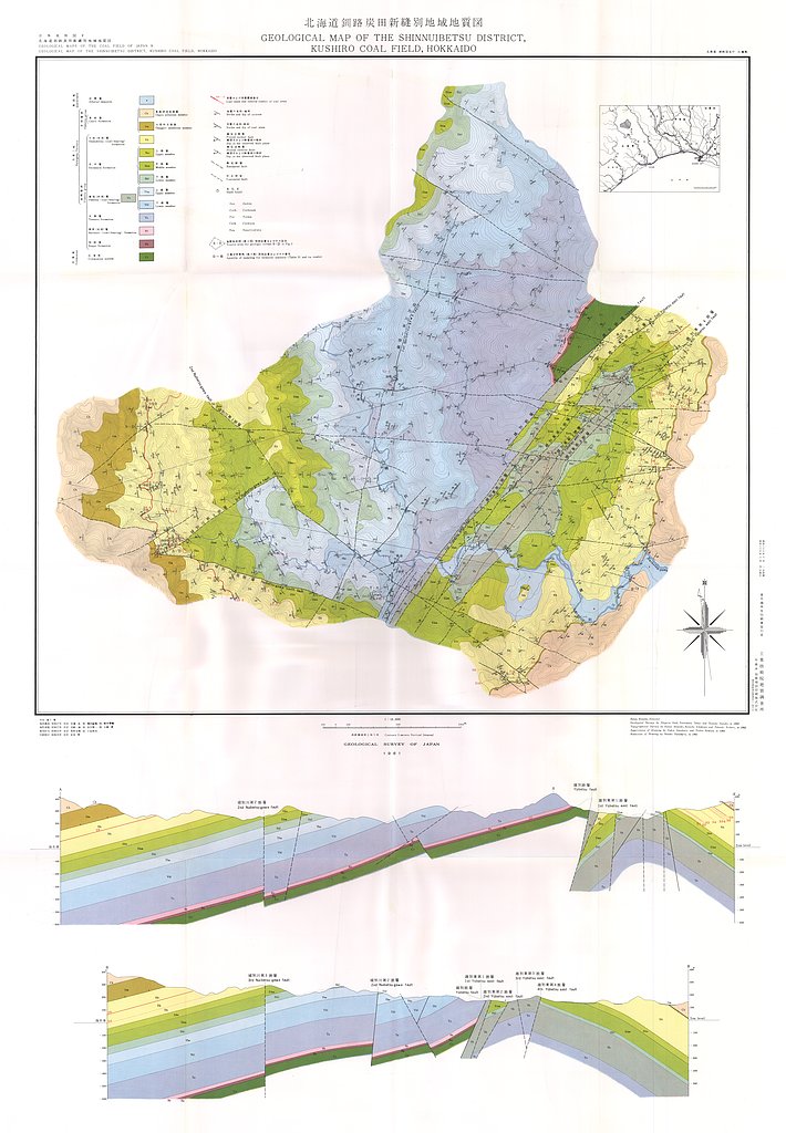
釧路炭田新縫別地域地質図,1:10,000 (1961)
地質調査総合センター名称: 釧路炭田新縫別地域地質図,1:10,000 / Geological Map and Explanatory Text of the Shinnuibetsu District, Kushiro Coal Field, Hokkaido,1:10,000 著者: 佐藤 茂, 棚井 敏雅, 鈴木 泰輔, 岩崎 一雄, 市川 賢一, 小張 孝 /... -
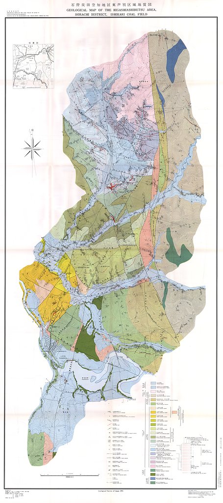
石狩炭田空知地区東芦別区域地質図,1:10,000 (1961)
地質調査総合センター名称: 石狩炭田空知地区東芦別区域地質図,1:10,000 / Geological Maps and Explanatory Text of the Higashiashibetsu Area, Sorachi District, Ishikari Coal Field,1:10,000 著者: 三田 正一, 小島 光夫, 佐々木 実, 沢田 秀穂,...